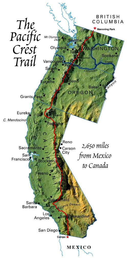
Trail facts: The Pacific Crest Trail is approximately 2,650 miles long and goes from the Mexican border (fence) at Campo, CA, through California, Oregon and Washington and ends at Manning Park, BC, Canada.
About 300 people attempt to thru-hike the PCT each year. 50-60% complete it.
The trail passes through 24 national forests, 37 wilderness areas, and 7 national parks. It climbs nearly 60 major mountain passes and descends into 19 major canyons and ambles by more than 1,000 lakes. The high point is Forrester Pass at 13,153' and the low point is near sea level at the Columbia River.
It was designated a National Scenic Trail in 1968 but not completed until 1993. It takes about 150 days to hike the distance (with about 20-30 non-hiking or "zero" days in the towns). Because of weather considerations, most thru-hikers go from South to North.
There are food resupply points along the way about every 3-9 days. Some hikers pre-mail food boxes to themselves to these points. Others shop at the local grocery store for supplies for the next segment. Those that complete the thru-hike will have climbed up 428,011 feet and descended 426,486 feet - that is the equivalent of almost 15 ascents of Mt Everest from sea level.
The Pacific Crest Trail starts out in the "Desert Section" from Campo to Kennedy Meadows (near Inyokern, CA) and for the first 700 miles we are in a dry, hot, section, hiking from water source to water source. We pass through Julian, Warner Springs, Idyllwild, Big Bear, across the Cajon Summit and under the I-15, Tehachapi, Onyx and up to Kennedy Meadows.
Next are the Sierras. We will be into our trip for about a month now, starting the Sierra segment at Kennedy Meadows, near Inyokern. The journey continues for another 400 miles with mostly high altitude hiking (high point on the PCT is Forrester Pass at 13,153' or 4,009 m). The amount of snow that falls each winter is the most important factor that determines when we plan to arrive at Kennedy Meadows. Above average snowfall poses many problems: mountain passes may be buried and impassable, the trail will be difficult or impossible to follow when it is buried under mounds of snow, river fords are dangerously swollen with meltwater and the trail may be treacherous because of icy slopes with boulders below.
See the mountain snowpack maps here. And, if you are really into it, you can look at the "Snow Water Equivalent" graphs. SWE is a measurement of the equivalent water in the snowpack. If you look at one station, Tuolumne Meadows, for example, you will see that the SWE is almost as high as it was last year in April! That means (as of Jan 7, 2011) that we are presently at 85% of the max for 2010 (17 inches divided by 20.3 inches (max for 2010). Please stop the snow!
Below average snowfall poses another problem: lack of available water. Thru-hikers hope for a normal snow year and keenly watch as the winter season preceeding the hike unfolds. Decisions about start dates, clothing, equipment and High Sierra entry are all determined by the preceeding winter season.
The path through the Sierras send us by Lone Pine, Mt. Whitney, Mammoth, Tuolumne Meadows, Sonora Pass, and South Lake Tahoe.
Then it is up through Northern California for another 750 miles to the Oregon border. We travel through such places as Soda Springs, Sierra City, Belden, Old Station, Dunsmuir, Mt. Shasta, and up to Ashland Oregon and Crater Lake.
When asked about the trail through California, the thru-hikers almost always reply "LONG!"
So, Oregon, entering at mile 1,730 --now less than 1,000 to go! Oregon (only 430 miles of trail) will go quickly with a crossing of the Columbia River at Cascade Locks (OR) to Stevenson, WA. Now the race is on to get through Washington (the final 500 miles) before the autumn cold and snow sets in. Up through Packwood, Snoqualmie Pass, Skykomish, Stehenkin, and finally (hopefully) Manning Park, British Columbia.
Is this a crazy bucket list idea or what!!!
See us on the google map (click on the "S" to zoom in)